Navarro Mills Lake (Trinity River Basin)
 Navarro Mills Lake and dam are located about sixteen miles southwest of the city of Corsicana in Navarro County, on Richland Creek, a tributary of the Trinity River. Navarro Mills Lake is owned by the U.S. Government and operated by the U.S. Army Corps of Engineers, Fort Worth District for flood control, water supply, and recreational purposes. The Trinity River Authority has the right to use water in the conservation pool. During 1940's and 1950's, some residents and community leaders in Navarro County recognized the potential demands for water supply due to population growth and formed a small alliance devoted to preparing the dam and lake.
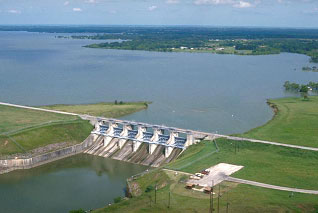
The project was authorized by the Flood Control Act of September 3, 1954, 83rd Congress, second session, and modified by the Flood Control Act of July 3, 1958, 85th Congress, second session. Construction began in December 23, 1959 and was completed in May 10, 1963. Deliberate impoundment of water began on March 15, 1963. The dam, including spillway, is approximately 7,570-foot long rolled-earth embankment with a maximum height above streambed of 81.7 feet. The top of the dam is at the elevation of 457 feet above mean sea level, while the maximum designed water surface is at the levation of 451.9 feet above mean sea level. The spillway is controlled by 6 tainter gates, each gate is 40 feet wide and 29 feet tall, and has a crest at an elevation of 414 feet above mean sea level. At the top of the flood control pool (top of gates), at an elevation of 443 feet above mean sea level, the lake covers 11,700 acres and stores 212,200 acre feet water. According to the TWDB 2008 volumetric survey, the lake has a storage capacity of 49,828 acre-feet, encompassing a surface area of 4,736 acres, at its conservation pool elevation of 424.5 feet above mean sea level. The dam controls a drainage area of approximately 320 square miles.