Lake Nasworthy (Colorado River Basin)
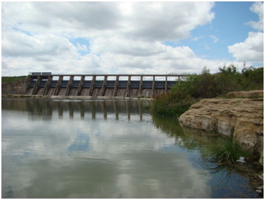 Lake Nasworthy is located approximately six miles southwest of San Angelo in Tom Green County, on the South Concho River, a tributary of the Concho River which is a tributary of the Colorado River. The lake is named for John R. Nasworthy who sold the land the lake is currently located on to the city. The project is owned by the city of San Angelo (originally by West Texas Utilities Company) for municipal and industrial water supply and recreational purposes. Authorization (Water Right Permit No. 1120) for the dam was issued by the State Board of Water Engineers in April 15, 1929. Construction of the dam started in January 1929 and was completed in June 1930. Deliberate impoundment of water began March 28, 1930. Nasworthy Dam is an earthfill embankment of 5,480 feet long (including spillways which is made by concrete) with a maximum height of about 50 feet. The top of the dam is at elevation, 1,883.5 feet above mean sea level. To the right of the earthfill dam section are located two uncontrolled emergency spillways. The first one is 300 feet wide with a crest elevation of 1,879.1 feet above mean sea level. The second is 1,300 feet wide with a crest elevation of 1,880.1 feet above mean sea level. The service spillway is a concrete ogee section located on the left side of the dam and is controlled by 15 tainter gates, each 25 feet wide and 18 feet high. The crest of service spillway is at elevation of 1,855.3 feet above mean sea level. To the left of the service spillway is located a 25-foot-wide auxiliary spillway equipped with a 3-foot-high collapsible floodgate set to open automatically when the water in the lake reaches an elevation of 1,872.4 feet above mean sea level. The crest of this auxiliary spillway is at elevation of 1,869.2 feet above mean sea level. According to TWDB 1993 survey, the lake has a capacity of 10,108 acre-feet encompassing a surface area of 1,380 acres at the top of the conservation pool, elevation 1,872.2 feet above mean sea level. The lake drains an area of 3,833 square miles, including the areas controlled by other lakes upstream.