Monticello Reservoir (Cypress River Basin)
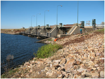 Monticello Reservoir is located approximately two and one-half miles east of Monticello in Titus County on Blundell Creek, a tributary of Big Cypress Creek. The dam and reservoir are owned and operated by Texas Utilities Electric Company for industrial purposes. The authorization to construct the dam was granted by the Texas Water Commission on July 24, 1970. Construction of the dam started on April 16, 1971 and deliberate impoundment began on August 9, 1972. The project was officially completed in spring 1973. Monticello Dam and appurtenant structures consist of a rolled earth fill embankment, approximately 3,200 feet in length. The embankment rises 54 feet above the natural streambed to an elevation of 352.0 feet above mean sea level. The service spillway is located at the left (east) abutment and is a concrete chute with an ogee crest. The crest is 160 feet in net length at elevation 328.0 feet. Four tainter gates, each 14 feet tall and 40 feet wide, control the service spillway. The emergency spillway, located to the right (west) of the dam, is an earth trench cut through the natural ground. The uncontrolled broad crested weir is 1,000 feet in length at elevation 343.5 feet. According to TWDB 1998 volumetric survey, the lake can store 34,740 acre-feet of water encompassing a surface area of 2,001 acres at its conservation pool elevation, 340 feet above mean sea level. The dam controls a drainage area of approximately 36 square miles.