Medina Lake (San Antonio River Basin)
 Medina Lake is located approximately eight miles northwest of Riomedina in Medina County, on the Medina River, a tributary (or upstream) of The San Antonio River. The lake extends into Bandera County. It is owned and operated by the Bexar-Medina-Atascosa Counties Water Improvement District No. 1 (BMA) for irrigational, municipal, industrial and recreational purposes. The project was built by the Medina Valley Irrigation Company (former BMA) under a Declaration of Appropriation filed November 16, 1910, which was converted to Certified Filling No. 18 by the State Board of Water Engineers on February 14, 1914.
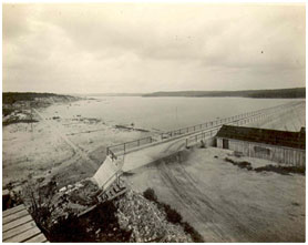
Construction of the dam started in November 1911 and was completed in 1913. Deliberate impoundment of water began on May 7, 1913. The Medina project includes Medina Dam and Medina Diversion Dam which is four miles downstream of Medina Dam and is for diverting water to the irrigation canal system. At the time, the Medina was the largest dam in Texas and the fourth largest in the United States. It is a gravity concrete structure of 1,580 feet long with a maximum height of 164 feet. The top of the dam is at elevation, 1,076.2 feet above mean sea level (NGVD29). The uncontrolled spillway is a cut through natural rock and is 880 feet long with a 3 foot wide cutoff wall located near the right end of the dam. The crest elevation is at 1,064.5 feet above mean sea level (NGVD29). According to TWDB 1995 survey, the lake has a capacity of 254,823 acre-feet encompassing a surface area of 6,066 acres at conservation pool elevation of 1,064.2 feet above mean sea level (NGVD29). At the same time, Medina Diversion Lake has a capacity of 2,555 acre-feet encompassing a surface area of 169 acres at normal elevation of 926.5 feet above mean sea level. The drainage area above the Medina Dam is approximately 634 square miles.