Lake Limestone (Brazos River Basin)
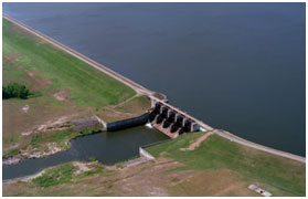 Sterling C. Robertson Dam is located about seven miles northwest of Marquez, crossing the border of Leon and Robertson Counties. It dammed the Navasota River, a tributary of the Brazos River, to form Lake Limestone, which lies mainly in Limestone County. The Brazos River Authority owns and operates the lake for water supply and recreational purposes. The Texas Water Rights Commission issued a permit to build this reservoir (Permit No. 5165) on May 6, 1974. Construction of the dam was completed in 1978. The Robertson dam is a zoned earthfill and concrete embankment of 8,500 feet in length including the service spillway. The top of the dam is at an elevation of 380 feet above mean sea level. Maximum design water surface may reach to 376 feet above mean sea level. The uncontrolled emergency spillway is located to the left of the dam and is unpaved broadcrested with the crest at an elevation of 370 feet above mean sea level. The 232 foot long service spillway is a type of gate-controlled concrete ogee consisting of five gates. Each gate measures 40 feet in width and 28 feet in height with the top of the gate at an elevation of 365 feet above mean sea level and the crest of the spillway at an elevation of 337 feet above mean sea level. According to the TWDB's 2012 Survey, the reservoir has a capacity of 203,780 acre-feet with a water surface area of 12,486 acres at the top of the conservation pool, with an elevation of 363 feet above mean sea level. The dam controls a drainage area of about 675 square miles.