Lake J. B. Thomas (Colorado River Basin)
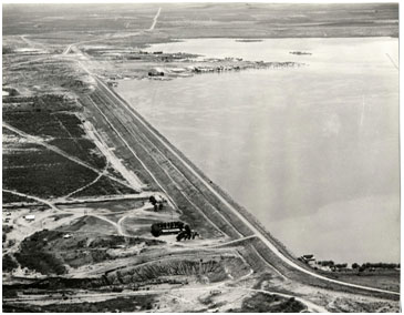 Lake J. B. Thomas (also known as Colorado River Dam) is located about sixteen miles southwest of Snyder in Scurry County, on the Colorado River. The lake extends into Borden County when water level is high. The lake was named after Julian B. Thomas, former President of Texas Electric Service Co. who fought hard for water supply for West Texas. The lake is owned and operated by the Colorado River Municipal Water District (CRMWD) for the purpose of supplying water to the District's member and customer cities. Authorization for the dam (Water Rights Permit No. 1394) was issued to CRMWD on August 19, 1946. Construction of the dam started on March 26, 1951. Deliberate impoundment of water began in July of 1952 and the project was completed in September of 1952. This dam was constructed by J.W. Moorman and Son, is approximately 14,500 feet long with a maximum height of 105 feet and an elevation of 2,280 feet above mean sea level. Maximum design water surface may reach to 2,275 feet above mean sea level. There are two emergency spillways, The north, or left, spillway is located at the left abutment of the dam with a crest length of 500 feet at elevation 2,264 feet above mean sea level. The south, or right, spillway is a cut channel, 3,500 feet to the right end of the dam with crest length of 1,600 feet at elevation 2,267 feet above mean sea level. The uncontrolled morning glory service spillway is rectangular drop inlet with crest at elevation of 2,258 feet above mean sea level. According to TWDB 1999 volumetric survey, the reservoir has a normal capacity of 200,604 acre-feet of water while covering approximately 7,282 acres at the elevation of 2,258 feet above mean sea level. The dam controls a drainage area of 3,524 square miles, of which 2,590 square miles is probably noncontributing.