Hubbard Creek Reservoir (Brazos River Basin)
 Hubbard Creek Reservoir is located about six miles northwest of Breckenridge in Stephens County, on Hubbard Creek, a tributary of the Brazos River. The lake is owned by the West Central Texas Municipal Water District for municipal, industrial, and mining supplies. Construction began in March 1, 1961 and the dam was completed in November 26, 1962. Deliberate impoundment began December 18, 1962. As stated in the TWDB 1997 survey report: "The dam and appurtenant structures consist of an earthfill embankment 15,150 feet in length (including levees) with a maximum height of 112 feet or elevation of 1,208.31 feet (NAVD88). The service spillway is a circular concrete drop inlet structure that is gate controlled. The crest elevation of the drop inlet is 1,176.81 feet (NAVD88) and the top of the gates is at an elevation of 1,185.31 feet (NAVD88). All water that enters the drop inlet is discharged through the embankment and exits downstream via a 22 foot diameter conduit. The low-flow outlet consists of a 48-inch diameter valve-controlled pipe with an invert elevation of 1,136.31 feet (NAVD88). The emergency spillway is a excavated broad-crested weir located near the left end of the dam. The 2,000 foot long weir is at an elevation of 1,194.31 feet (NAVD88). Also, incorporated in the emergency spillway is a 4,000 foot long fuse plug with a crest elevation of 1,197.31 feet (NAVD88). According to TWDB 2018 survey, reservoir had a conservation storage capacity of 318,174 acre-feet and a conservation surface area of 15,687 acres at an elevation of 1,183.31 feet above mean sea level (NAVD88). The drainage area of the reservoir is 1,107 square miles.
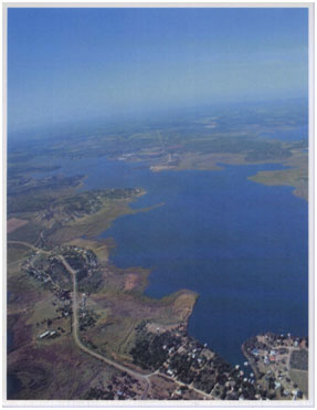