Eagle Mountain Dam and Lake (Trinity River Basin)
 Eagle Mountain Dam and Lake (formerly Eagle Mountain Reservoir) are located about 5 miles northwest of Fort Worth, on the West Fork Trinity River just north of Lake Worth in northwestern Tarrant County. It is owned and operated by the Tarrant Regional Water District for flood control, water supply, irrigation, and recreational purposes. Permit for constructing the dam was authorized by State Board of Water Engineers on May 1, 1928. Construction of the dam began on January 23, 1930, and was completed October 24, 1932.
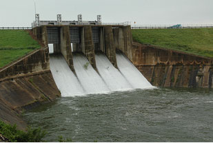
Deliberate impoundment of water began on February 28, 1934. The dam is 85 feet high and 4,800 feet long with the top of dam at an elevation of 682 feet above mean sea level. Maximum designed water surface may reach 680.23 feet above mean sea level. The emergency spillway is on natural ground located between the dam and concrete spillway with a width of 1,300 feet and a crest elevation at 676 feet above mean sea level (at the top of fuse plug which is measure 6 feet height). On July 31, 1971, construction on a new service spillway was completed by adding a new concrete side channel ogee to control the discharge through a 25 feet square conduit. The crest of this new 6-roller gate controlled service spillway is at 637 feet above mean sea level, with the top of gate at 659 feet above mean sea level. The crest of the old service 4-vertical lift gate controlled service spillway (shown in the photo above) is at 649.1 feet above mean sea level. According to TWDB 2018 survey, the reservoir has a normal capacity of 185,087 acre-feet and encompasses 9,246 acres at conservation pool elevation (649.1 feet NAVD88). The drainage area of the West Fork of the Trinity River at Eagle Mountain Dam is 1,970 square miles.