Lake Anahuac (Trinity River Basin)
 Lake Anahuac (also known as Turtle Bay) is located north of Anahuac in western Chambers County on the Turtle Bayou but is mainly fed by the Trinity River through Big Hog Bayou, by pumping if necessary. It is owned and operated by the Chambers-Liberty County Navigation District for municipal, irrigation, industrial, and mining supply purposes. In 1900 the Farmers Canal Company began pumping water out of what was then called Turtle Bay to irrigate rice fields.
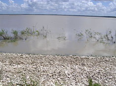
The depletion of fresh water led to an encroachment of salt water, which in turn forced the newly formed Trinity River Irrigation District to construct a barrier across the mouth of the bay; the bay had been declared non-navigable in 1902. In 1915 a hurricane destroyed the bulkhead, and salt water again threatened both the bay's ecology and area farmers. In 1931 the Lone Star Canal Company began rebuilding the saltwater barrier. Despite protests from oil, shell, and barge companies, the United States War Department decided to close the entrance to Turtle Bay in 1936. Construction of a new dam, levee, and spillway began on March 17, 1953; by that time the reservoir had been named Lake Anahuac. The ten-foot hydraulic earthfill embankment, completed in July 1954, measures 59,000 feet long including spillways. The top of the embankment/levee is at elevation of 9 feet above mean sea level. The uncontrolled emergency spillway is measured at 1,200 feet long with crest at an elevation of 8 feet above mean sea level. The 700 feet long service spillway is uncontrolled and is a concrete slab with crest at an elevation of 5 feet above mean sea level. According to TWDB 2006 survey, the lake has a storage capacity of approximately 33,348 acre-feet, encompassing a surface area of 5,035 acres at elevation of 4 feet above mean sea level. The lake has a drainage area of approximately 199 square miles from the Turtle Bayou watershed.