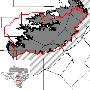
Hill Country portion of the Trinity Aquifer Groundwater Availability Model (GAM)
 The Texas Water Development Board (TWDB) completed this model in 2000 in cooperation with the Trinity Aquifer Advisory Committee which includes members of local groundwater districts, river authorities, county governments, regional water planning groups, and concerned citizens.
In 2009, the TWDB completed an update to the model to include the Lower Trinity as a fourth model layer.
In 2017, the TWDB contracted with Southwest Research Institute to update the conceptual model for the Trinity Aquifer in the Hill Country region with the goal of incorporating the Trinity strata to the east into the Hill County Trinity GAM. The project is expected to be completed in 2019.
The report of the updated conceptual model for the Trinity Aquifer in the Hill Country region is available below.
Conceptual Model Report
Conceptual Model Report for the Hill Country Trinity Aquifer Groundwater Availability Model
Stakeholder Advisory Forums (SAF)
Send us an email if you would like to receive SAF notifications.
| ID | Date | Location |
|---|---|---|
| SAF 1 | 6/5/2017 | San Antonio, Texas - Southwest Research Institute |
| SAF 2 | 7/13/2018 | San Antonio, Texas - Southwest Research Institute |
Model Report
"Groundwater Availability of the Trinity Aquifer, Hill Country Area, Texas: Numerical Simulations through 2050." - Original model
"Groundwater Availability Model for the Hill Country Portion of the Trinity Aquifer System, Texas." - Updated model
Model Files and Associated Data
Please see the GAM files download page for a copy of the model files..
Aquifer data is only available as a package for the entire model area and requires GIS software for processing. Please see the GAM files download page for aquifer data.
Stakeholder Advisory Forums (SAF)
Send us an email if you would like to receive SAF notifications.
| ID | Date | Location |
|---|---|---|
| SAF 3 | 8/17/2009 | Kerrville, Texas - Upper Guadalupe River Authority Auditorium (125 Lehmann Dr) |
| SAF 2 | 12/12/2006 | Johnson City, Texas - Blanco-Pedernales Groundwater Conservation District (601 West Main) |
| SAF 1 | 6/7/2005 | Boerne, Texas - Kendall County Historic Courthouse |
Other Resources
Please see the Trinity Aquifer page for other reports and publications.
For model runs see the GMA 9 page.