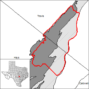
Barton Springs segment of the Edwards (Balcones Fault Zone) Aquifer Groundwater Availability Model (GAM)
 The Bureau of Economic Geology in cooperation with the Lower Colorado River Authority have developed a GAM for the Barton Springs segment of the Edwards Aquifer (Scanlon and others, 2001).
The model: 1) has a minimum grid resolution of 500 feet, 2) explicitly represents the aquifer thickness in the simulation, 3) simulates transient flow for a long time (10 years), and 4) predicts groundwater availability under increased pumpage and potential future droughts for the period through 2050. The spatially distributed model developed in this study allows the effect of pumpage in different regions of the model area to be assessed.
Current GAM
Model Report
Model Files and Associated Data
Please see the GAM files download page for the current model files and associated data.
Aquifer data is only available as a package for the entire model area and requires GIS software for processing. Please see the GAM files download page for the aquifer data.
Stakeholder Advisory Forums (SAF)
Send us an email if you would like to receive SAF notifications.
| ID | Date | Location |
|---|---|---|
| SAF 2 | 1/8/2009 | Austin, Texas - Barton Springs Edwards Aquifer Conservation District (1124 Regal Row, Austin, TX, 78748) |
| SAF 1 | 5/28/2008 | Austin, Texas - Stephen F. Austin Building (1700 North Congress Avenue) |
Other Resources
Please see the Edwards (Balcones Fault Zone) Aquifer and the Barton Springs Segment of the Edwards (Balcones Fault Zone) Aquifer Alternative Groundwater Flow Model pages for other reports and publications.
For model runs see the GMA 10 page.