Region 7 Upper Brazos Flood Planning Region
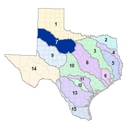 Originating near Lubbock, the Brazos river�s Salt Fork and Double Mountain Fork track east across the High and Rolling Plains ecoregions of West Texas, converging in Stonewall County. The main stem of the Brazos then merges with the Clear Fork in the Cross Timbers ecoregion of southern Young County before entering Possum Kingdom Lake in the adjacent Region 8 Lower Brazos. There are 14 major lakes and reservoirs in Region 7.
For a detailed map of Region 7, please visit the Texas Geographic Information Office (TxGIO) Flood Planning Regions Map Collection.
Go to Region 7 Upper Brazos RFPG External Host Website
Population Estimate (2019): 633,584
Approximate Area: 20,085 square miles
Approximate Stream Miles: 9,744
Approximate NFIP Claims (1975-2019): $25,575,499
Counties Represented:
- Archer*
- Bailey
- Baylor*
- Borden*
- Callahan*
- Castro*
- Cochran*
- Crosby*
- Dawson*
- Dickens*
- Eastland*
- Fisher
- Floyd*
- Garza*
- Hale*
- Haskell
- Hockley*
- Jones
- Kent
- King*
- Knox*
- Lamb
- Lubbock
- Lynn*
- Mitchell*
- Nolan*
- Parmer*
- Scurry*
- Shackelford
- Stephens*
- Stonewall
- Swisher*
- Taylor*
- Terry*
- Throckmorton
- Young*
*indicates this county is partially within this RFPG and is also represented by at least one other RFPG
Major Cities (Population greater than 25,000):
- Abilene
- Lubbock
Major Lakes & Reservoirs:
- Alan Henry Reservoir
- Hubbard Creek Reservoir
- Lake Abilene
- Lake Cisco
- Lake Daniel
- Lake Davis
- Lake Fort Phantom Hill
- Lake Kirby
- Lake Stamford
- Lake Sweetwater
- Lower Running Water Draw WS SCS Site 2
- Lower Running Water Draw WS SCS Site 3
- Millers Creek Reservoir
- White River Lake
Ecoregions of Texas Represented:
- Cross Timbers
- Edwards Plateau
- High Plains
- Rolling Plains
Regional Flood Planning Group Meeting Minutes & Updates
Please see the RFPG Meeting Schedule webpage for information on the past and upcoming meetings.
Contacts
Planning Group Sponsor Contact: South Plains Association of Governments, Kelly Davila, (806) 762-8721
Planning Group Chair: Michael Keenum, (806) 775-2393
TWDB Contact:Sarah Magana, (512) 475 1656