Region 6 San Jacinto Flood Planning Region
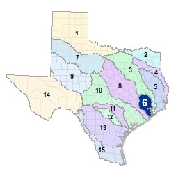 As the San Jacinto River and its many contributing creeks and bayous traverse south from the Huntsville area, its waters cross through the Piney Woods ecoregion and the Sam Houston National Forest. The river then flows across the Gulf Prairies to Galveston Bay. There are eight major lakes and reservoirs in the San Jacinto river basin, and it is the second most populated flood planning region which is also home to the fourth largest city in the United States: Houston.
For a detailed map of Region 6, please visit the Texas Geographic Information Office (TxGIO) Flood Planning Regions Map Collection.
Go to Region 6 San Jacinto RFPG External Host Website
Population Estimate (2019): 6,297,609
Approximate Area: 5,089 square miles
Approximate Stream Miles: 3,696
Approximate NFIP Claims (1975-2019): $11,661,576,868
Counties Represented:
- Brazoria*
- Chambers*
- Fort Bend*
- Galveston*
- Grimes*
- Harris*
- Liberty*
- Montgomery
- San Jacinto*
- Walker*
- Waller*
*indicates this county is partially within this RFPG and is also represented by at least one other RFPG
Major Cities (Population greater than 25,000):
- Alvin*
- Atascocita
- Baytown
- Channelview
- Conroe
- Deer Park
- Friendswood
- Galveston
- Houston
- Huntsville*
- La Porte
- League City
- Mission Bend
- Missouri City*
- Pasadena
- Pearland
- Spring
- Sugar Land*
- Texas City
- The Woodlands
*indicates this city is partially within this RFPG and is also represented by at least one other RFPG
Major Lakes & Reservoirs:
- Addicks Reservoir
- Barker Reservoir
- Gulf Coast Water Authority Reservoir
- Lake Conroe
- Lake Houston
- Lewis Creek Reservoir
- Mustang Lake East/Mustang Lake West
- Sheldon Reservoir
Ecoregions of Texas Represented:
- Blackland Prairie
- Gulf Prairies
- Piney Woods
- Post Oak Savanah
Regional Flood Planning Group Meeting Minutes & Updates
Please see the RFPG Meeting Schedule webpage for information on the past and upcoming meetings.
Contacts
Planning Group Sponsor Contact: Harris County, SJR Flood Planning Group
Planning Group Chair: Timothy Buscha, P.E., (832) 590-7255
TWDB Contact:Nick Collins, (512) 475-1705