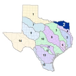
Region 2 Lower Red-Sulphur-Cypress Flood Planning Region
 Twenty-one (21) major lakes and reservoirs are found in this region in the northeast corner of the state, which borders Oklahoma to the north and Louisiana to the east. After leaving Lake Texoma, the lower Red River is fed by numerous creeks and tributaries on its way to the Louisiana border. The Sulphur River and its tributaries run from west to east where it serves as the border between Bowie and Cass counties before entering Louisiana. Cypress Creek (sometimes called Cypress Bayou) flows across this region to its confluence with the Red River in Louisiana. Along the way, it flows through Caddo Lake, one of the state's only natural lakes.
For a detailed map of Region 2, please visit the Texas Geographic Information Office (TxGIO) Flood Planning Regions Map Collection.
Go to Region 2 Lower Red-Sulphur-Cypress RFPG External Host Website
Population Estimate (2019): 515,732
Approximate Area: 9,187 square miles
Approximate Stream Miles: 7,380
Approximate NFIP Claims (1975-2019): $30,509,198
Counties Represented:
- Bowie
- Camp
- Cass
- Cooke*
- Delta
- Fannin*
- Franklin*
- Grayson*
- Gregg*
- Harrison*
- Hopkins*
- Hunt*
- Lamar
- Marion
- Morris
- Panola*
- Red River
- Titus
- Upshur*
- Wood
*indicates this county is partially within this RFPG and is also represented by at least one other RFPG
Major Cities (Population greater than 25,000):
- Sherman
- Texarkana
Major Lakes & Reservoirs:
- Caddo Lake
- Coffee Mill Lake
- Ellison Creek Reservoir
- Jim Chapman Lake
- Johnson Creek Reservoir
- Lake Bob Sandlin
- Lake Bonham
- Lake Crook
- Lake Cypress Springs
- Lake Gilmer
- Lake O' The Pines
- Lake Sulphur Springs
- Lake Texoma
- Monticello Reservoir
- Pat Mayse Lake
- Peacock Site 1a Tailings Reservoir
- Randell Lake
- River Crest Lake
- Valley lake
- Welsh Reservoir
- Wright Patman Lake
Ecoregions of Texas Represented:
- Blackland Prairie
- Cross Timbers
- Piney Woods
- Post Oak Savanah
Regional Flood Planning Group Meeting Minutes & Updates
Please see the RFPG Meeting Schedule webpage for information on the past and upcoming meetings.
Contacts
Planning Group Sponsor Contact: Ark-Tex Council of Governments, Mary Beth Rudel, (903) 255-3520 or Paul Prange, (903) 255-3519
Planning Group Chair: Reeves Hayter, (903) 517-8633
TWDB Contact:Cynthia Nolasco, (512) 475-1806