Proctor Lake (Brazos River Basin)
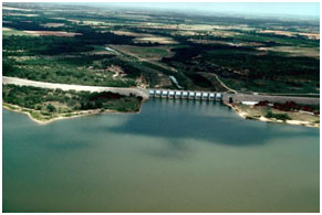 Proctor Lake is located approximately three miles northwest of the city of Proctor in the Comanche County, on Leon River, a tributary of the Little River which is a tributary to the Brazos River. The lake was built, and is owned by the United State of America and operated by the U.S. Army Corps of Engineers for flood control, water supply, and recreational purposes. Authorization of the dam was issued by Federal Flood Control Act 1954, and the Public Works Appropriations Act of 1957. Construction began in June 1960 and was placed in operation in 1963. The earthfilled dam, including spillway, is 13,460 feet long with a maximum height of 86 feet above the streambed. The top of the dam is at an elevation of 1,206 feet above mean sea level. The maximum design water surface may reach up to 1,201 feet above mean sea level. The spillway is concrete ogee weir controlled by eleven tainter gates, each 40 feet wide and 35 feet tall. The crest is at an elevation of 1,162 feet above mean sea level. Based on data from 1946 survey, at the top of the flood control pool, at an elevation 1,197 feet above mean sea level, the lake will cover 14,010 acres and stores 374,200 acre-feet water. According to the TWDB 2012 volumetric survey, at the top of the conservation pool, at an elevation of 1,162 feet above mean sea level, the lake has a capacity of 54,762 acre feet encompassing a water surface of 4,615 acres. The dam controls a drainage area of about 1,265 square miles.