Lake Marble Falls (Colorado River Basin)
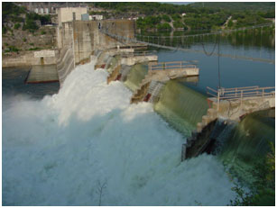 Lake Marble Falls (also known as Max Starcke Dam) is located near town of Marble Falls in Burnet County, on the Colorado River. The reservoir is owned and operated by the Lower Colorado River Authority for the primary purposes of generating hydroelectric power and water supply. Max Starcke Dam, originally named Marble Falls Dam, was renamed in 1962 for Max Starcke, the second general director of the LCRA. The project was authorized by Permit No. 998 dated November 4, 1927 from the State Board of Water Engineers. Construction of the dam started in November 1949 and was completed in October 1951. Deliberate impoundment of water began in July 1951. The dam is a concrete gravity structure of 860 feet long including the spillway, powerhouse, and other facilities. The top of the dam is at elevation, 738 feet above mean sea level. Spillway is controlled by 10 roof-weir floodgates, each 60 feet wide and 15 feet high, with a crest at elevation, 725 feet above mean sea level. Maximum design water surface is 758 feet above mean sea level, while design 100-year flood level at dam is 754.3 feet above mean sea level. Recorded historic high water level is 756.3 feet above mean sea level on Sept. 11, 1952. According to TWDB 2007 volumetric survey, the lake has a capacity of 7,486 acre-feet encompassing a surface area of 608 acres at the elevation of 738 feet above mean sea level. The drainage area above the dam is 36,325 square miles, of which 11,900 square miles is noncontributing. The water level in the lake is regulated by upstream reservoirs and power plant operation.