Survey Services
Volumetric Survey
Survey data collected with a Specialty Devices Inc, single-beam, multi-frequency (208 kHz, 50 kHz, and 12 kHz) sub-bottom profiling depth sounder. Analysis of only the 208 kHz frequency for the current bathymetric or bottom surface of the reservoir. Includes standard products such as contour map and updated elevation-area-capacity tables.
Sedimentation Survey
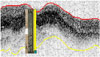
Survey data collected with a Specialty Devices Inc, single-beam, multi-frequency (208 kHz, 50 kHz, and 12 kHz) sub-bottom profiling depth sounder. Analysis of all three frequencies correlated with sediment core samples for current bathymetric surface and pre-impoundment reservoir surface. In addition to standard products, sedimentation rates and a sediment thickness map are provided.
Multi-Beam Survey
High resolution bathymetric data collection using multiple beams rather than a single beam system such as that used for a volumetric and sedimentation survey. Provides current bathymetric surface only.
* The above standard charge schedule represents the typical cost-recovery charges that would be made by the Texas Water Development Board (TWDB) for a "standardized" underwater bathymetric survey of a given size reservoir and associated reporting of the findings. Every reservoir is different in its size, dimensions, bottom terrain, ease of surveying, and particular surveying needs. This standard charge schedule assumes: a surface acreage of the reservoir at normal pool elevation; an underwater bathymetric survey only; a 500-feet average distance between the surveying transects; acceptable weather conditions; no significant surface or sub-surface obstructions to navigation; no unusual owner-induced delays once the field mobilization and survey effort has been initiated; a coordination meeting with the owner; three copies of a standard survey report consisting of a description of the reservoir and previously-known physical and storage conditions, description of the hydrographic survey methodology, narrative and tabular descriptions of the newly surveyed physical parameters of the reservoir bathymetry and storage capacity, a two-dimensional contour map, and associated digital files of the survey results. Representative cross-sections, or sediment range line profiles, may be provided if requested.
Given the variety of particular reservoir conditions, desires for greater or lesser accuracy than the standard transect-spacing quoted above, alternative means of accomplishing any needed above-the-water surveys, and various potential specialty studies, the TWDB offers other negotiated survey, study, or product services on an as-needed, expanded-effort basis. On a limited basis, a survey may be performed by the TWDB below the standard charge schedule in conjunction with marketing initiatives of the program for reservoirs less than 2,000 surface acres in size, but not at less than the TWDB's direct costs.