Inks Lake (Colorado River Basin)
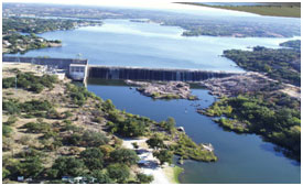 Inks Lake (also known as Roy Inks Dam) is located about ten miles west of Burnet in Burnet and Llano counties, on the Colorado River. The Lake is owned and operated by the Lower Colorado River Authority for hydropower generation and recreational purposes, together with other Highland Lakes as a system. The lake and dam are named after Roy B. Inks, one of the original directors on the Lower Colorado River Authority Board. Construction on the Dam, begun in 1936 and was completed in 1938. The dam is a concrete gravity structure of 1,547.5 feet long with a maximum height of 96.5 feet. The top of the dam is at elevation of 922 feet above mean sea level. Although the 100-year designed flood level is 901.7 feet above mean sea level, the dam is standing well at recorded flood peaked at 902.8 feet above mean sea level on July 25, 1938. The uncontrolled emergency spillway is located concrete gravity section of the dam with its crest at elevation of 888.3 feet above mean sea level. According to the TWDB 2007 survey, the lake has a capacity of 14,074 acre-feet encompassing a surface area of 788 acres at normal pool elevation of 888.22 feet above mean sea level. The drainage area is 31,290 square miles, of which 11,900 square miles is probably noncontributing. This lake is considered a constant-level one because the normal turbine discharge is coordinated with the inflow from Lake Buchanan so that normal fluctuation is small. However, during periods of floods the lake level varies considerably.