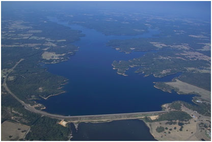
Lake Cypress Springs (Cypress River Basin)
 Lake Cypress Springs (also known as Franklin County Dam) is located approximately eight miles south of Mt. Vernon in Franklin County on Big Cypress Creek, a tributary of the Cypress Bayou. The lake is owned and operated by Franklin County Water District (FCWD) for the purposes of municipal and industrial water supply and public recreation. Authorization for constructing the dam and impounding up to 72,800 acre feet of water was granted on November 10, 1966 to the owner. Designed by engineers from Wisenbaker, Fix, and Associates, the dam construction by general contractor, Vibig Construction Company started in July 1968. Deliberate impoundment began on July 7, 1970 and the construction was officially completed on February 15, 1971. It has a watershed area of approximately 75 square miles and a shoreline length of 43 miles. The dam is a kind of earthfill embankment of 5,230 feet long with its top crest at the elevation of 395 feet above mean sea level. The uncontrolled emergency spillway is excavated on natural ground to the left side of the dam with a crest at an elevation of 385 feet above mean sea level. The service spillway is located in the right end of main embankment and is an uncontrolled rectangular drop inlet (23 by 23 feet) with a crest elevation of 378 feet above mean sea level. Based on the latest survey by Texas Water Development Board in 2007, the lake has a total storage capacity of 66,756 acre-feet, encompassing a surface area of 3,252 acres, at the conservation pool elevation, 378 feet above mean sea level (NGVD29). The sediment rate for the reservoir is approximately 100 acre feet per year.