Bardwell Lake (Trinity River Basin)
 Bardwell Lake and Dam is located about five miles south of the city of Ennis in Ellis County, on Waxahachie Creek five miles above its confluence with Chamber Creek, a tributary of the Trinity River. Federal authorization was granted for the Bardwell Lake facility under the Flood Control Act of March 31, 1960. The U. S. Army Corps of Engineers designed the project and M & S Construction Company was the general contractor. Construction of the dam began on August 28, 1963 and was completed on March 27, 1966. Deliberate impoundment of water began November 20, 1965. The reservoir is owned by the U. S Government and operated by the U.S. Army Corps of Engineers for the purposes of municipal water supply, flood control, and recreation.
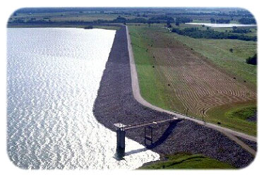
The maximum height of the dam is 82 feet above the streambed and its length is 15,400 feet. The top of the dam is at elevation of 460.0 feet above mean sea level, while maximum design water surface may reach to 455.9 feet above mean sea level. The project has a 350-foot wide uncontrolled emergency spillway with a crest elevation of 439.0 feet above mean sea level and controls run-off from 178 square miles of drainage area. At the top of flood control pool where elevation is 439.0 feet above mean sea level, the Bardwell Lake can store a total of 140,000 acre-feet water with a surface area of approximately 6,040 acres. According to the TWDB 1999 survey, the lake has a normal capacity of 46,472 acre-feet, encompassing a surface area of 3,138 acres at its conservation pool elevation, 421 feet above mean sea level.