Balmorhea Lake (Rio Grande River Basin)
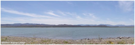 Balmorhea Lake (also known as Lower Parks Reservoir) is located two miles southeast of Balmorhea in Reeves County, on Sandia Creek, a tributary of the Peco River which is a tributary of the Rio Grande. The reservoir is owned and operated by the Reeves County Water Improvement District for irrigational and recreational purposes. Authorized by Permit No. 57 issued by the State Board of Water Engineers on March 6, 1915, the construction started in 1916 and was completed in 1917. Deliberate impoundment of water began in the same time. The dam is earthfill with clay core about 4000 feet long 46 feet high. The top of the dam is at elevation of 3,192 feet above mean sea level. An uncontrolled spillway is located at the right end of the embankment and is cut over the natural ground with a crest at elevation of 3,191 feet above mean sea level. The reservoir has a capacity of 6,350 acre-feet encompassing a surface area of 573 acres at the conservation pool elevation of 3,187 feet above mean sea level. The drainage area is approximately 22 square miles. However, water from Toyah Creek, fed by the nearby San Solomon Springs, is also fed into the reservoir, as is excess water in the Phantom Lake Canal.